
Read Time: 14 minutes
TL;DR
A superyacht is one of the most private things money can buy, and one of the easiest things in the world to find. Every large vessel broadcasts its identity, position, course, and destination in the clear over VHF radio, because a collision-avoidance safety system — AIS — requires it. Four free websites — MarineTraffic, VesselFinder, ShipFinder, and Maritime Database — turn that firehose into a searchable map where a single anchorage off Mallorca becomes a labeled guest list of the world’s wealthy, each hull tagged with its past track, its next port, and a route forecast button. Owner directories close the last gap from hull to human. And you don’t even need the websites: a ~200€ PortaPack decodes AIS straight off the air, which means suppressing your boat online does nothing about the radio that is still transmitting it. Now add AI, and the game changes shape: an agent fuses AIS with ownership records, news, and social posts into a live dossier, learns a target’s pattern-of-life, predicts the next anchorage, and pings you the moment the vessel appears — unattended. This is a security piece, not a how-to. It is written for the people who own, run, and protect these vessels, because a predicted anchorage is a location for a person. Method at the threat-vector level, defenses at the end, no targets named.
Disclaimer. This is defense-oriented and kept at the threat-vector level. It uses only publicly available data and public tools, names no human target, and pairs every capability with a countermeasure. The goal is OPSEC and executive-protection awareness for the people who own, crew, or protect these vessels — not a manual for anyone with worse intentions. As with the rest of the SRF-IWS series, I lean on AI to help build realistic, defense-oriented scenarios, and every vessel name shown here is already public on the platforms in the screenshots.
I have spent this blog crawling networks, hardware, and now AI agents looking for the place where a system leaks more than its owner thinks. The sea turned out to be one of the most generous leaks I have ever looked at — and unlike a misconfigured server, this one leaks by law.
Let me show you what an afternoon, a browser, a cheap radio, and an AI agent can reconstruct about where the wealthy actually are.
The marina is a guest list
Point any of these tools at Puerto Portals or the bay off Palmanova on a summer evening and the map does something a little obscene: it labels the anchorage. Not “yacht.” The names. A screen full of them, each one a hull worth tens or hundreds of millions, each one clickable.
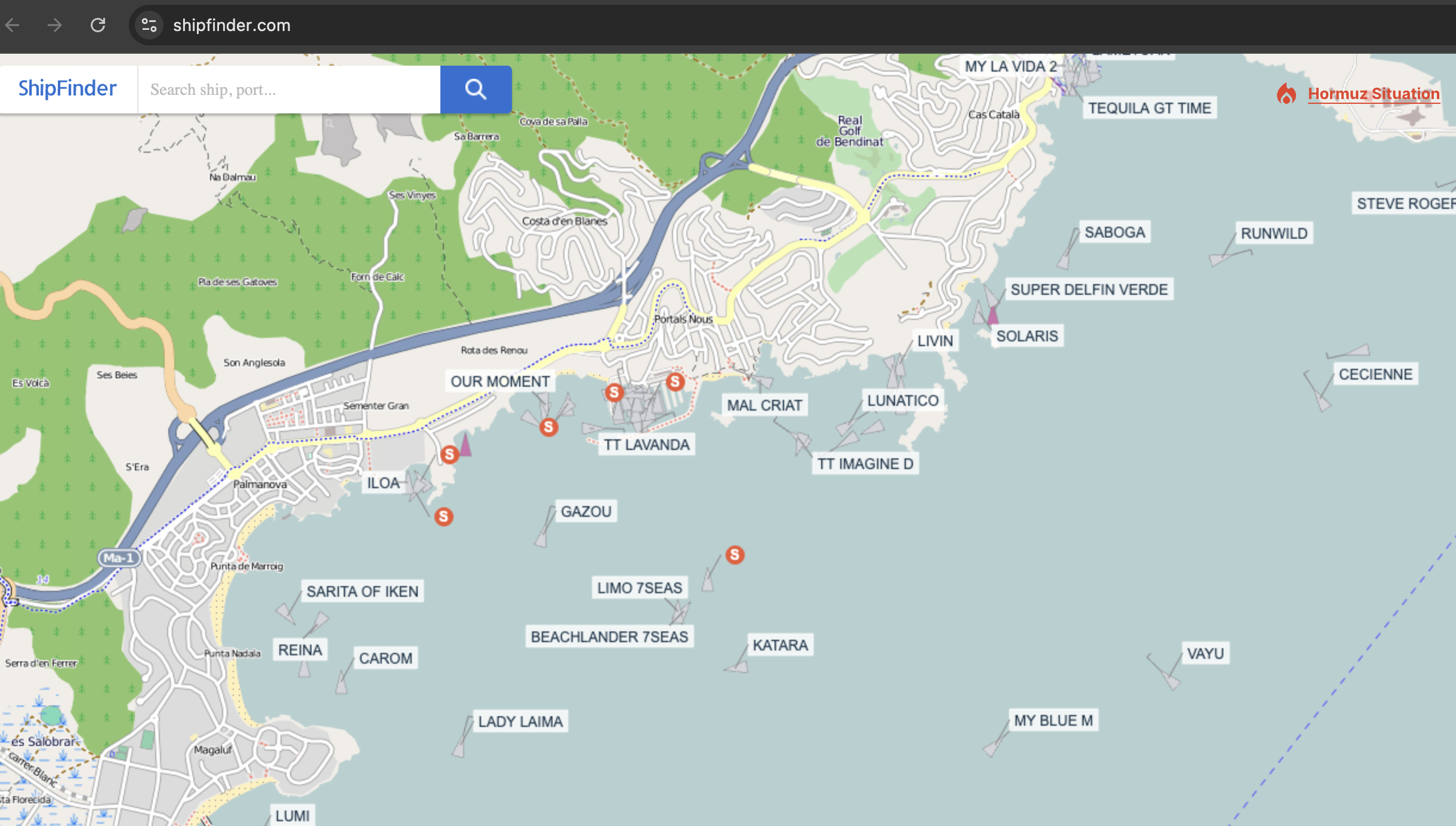
Figure 1. A free website turns a summer anchorage off Mallorca into a labeled guest list.
That is not a leak in the hacking sense. Nobody broke anything. That is the system working exactly as designed — which is the whole point, and the whole problem.
Why the sea has no privacy: AIS
The Automatic Identification System exists for a good reason: ships hitting each other in the dark is bad, so since the SOLAS convention, vessels above a certain size (and effectively every serious yacht) carry an AIS transponder that continuously broadcasts, over marine VHF, who they are and where they are. Identity (name, callsign, MMSI, IMO number), position, course, speed, navigational status, and often the destination they typed in — all in the clear, as often as every few seconds when a vessel is under way, to anyone listening.
There’s a size line worth knowing, because it decides who can’t opt out. Under SOLAS, a Class A transponder is mandatory for vessels over 300 gross tons and all passenger ships; smaller pleasure craft use the lighter, largely voluntary Class B, which can legally be switched off. Notice which side of that line the interesting boats fall on: essentially every superyacht in these screenshots is well over 300 GT, so the biggest, most-protected hulls on the water are precisely the ones the law forbids from going dark.
It is a safety beacon. It is also a tracking beacon. Those are the same signal. A technology built so a tanker doesn’t run down a fishing boat is, from the OSINT chair, a fleet of the world’s richest people voluntarily announcing their coordinates on an open channel.
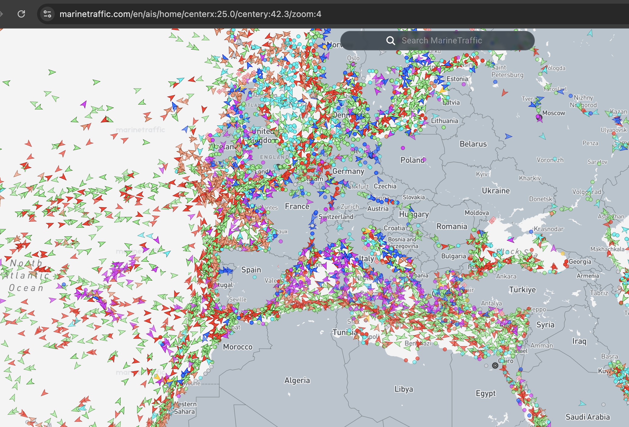
Figure 2. The raw AIS firehose across the Mediterranean — thousands of vessels, all self-reporting.
At this zoom it is just noise. The tools exist to turn the noise into an address.
The toolkit: turning the firehose into a map
The aggregators all do the same core thing — ingest global AIS (from terrestrial receivers and satellites) and render it as a live, searchable map — and you use several of them precisely because they disagree at the edges, which is how you cross-verify. MarineTraffic, VesselFinder, and ShipFinder are the big three; Maritime Database is the reference layer that gives you baselines on ports and vessel classes. All freemium: the map is free, the deep history and the exact live coordinates sit behind a subscription. And because the feeds come from satellites as well as shore receivers, coverage isn’t only coastal — anchoring offshore, out of anyone’s VHF range, does not take a vessel off these maps.
The method is a funnel. Start global, zoom to a region known for money, then to a specific marina.
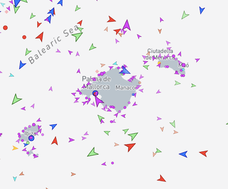
Figure 3. Zoom to the Balearics and the pleasure-craft layer (purple) separates from commercial traffic.
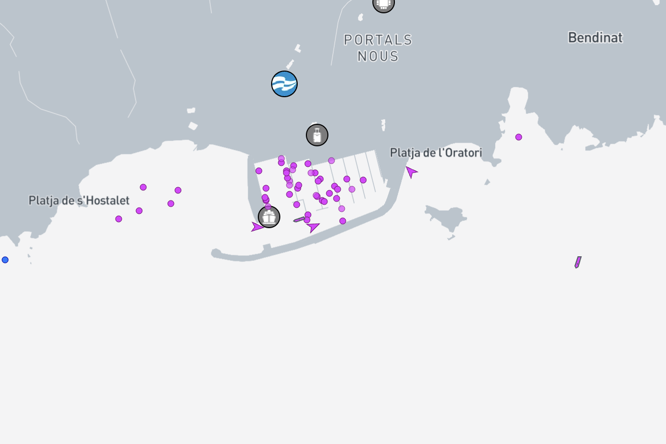
Figure 4. Three clicks from “somewhere in Europe” to a specific berth in Puerto Portals.
Three clicks from “somewhere in Europe” to “this specific berth.” Cross-check the same spot on VesselFinder and ShipFinder and the picture firms up.
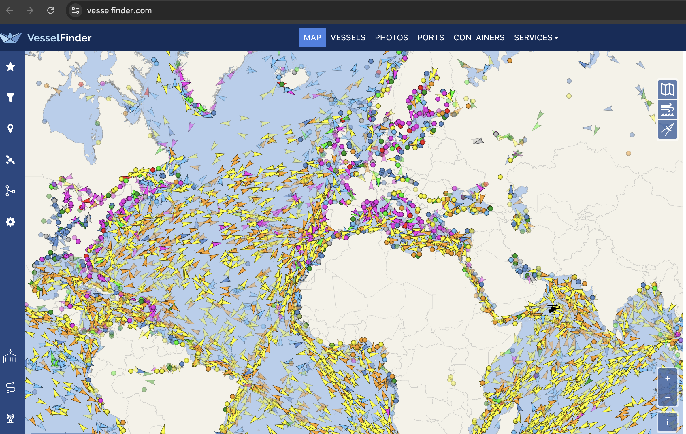
Figure 5. VesselFinder — a second aggregator to cross-verify against.
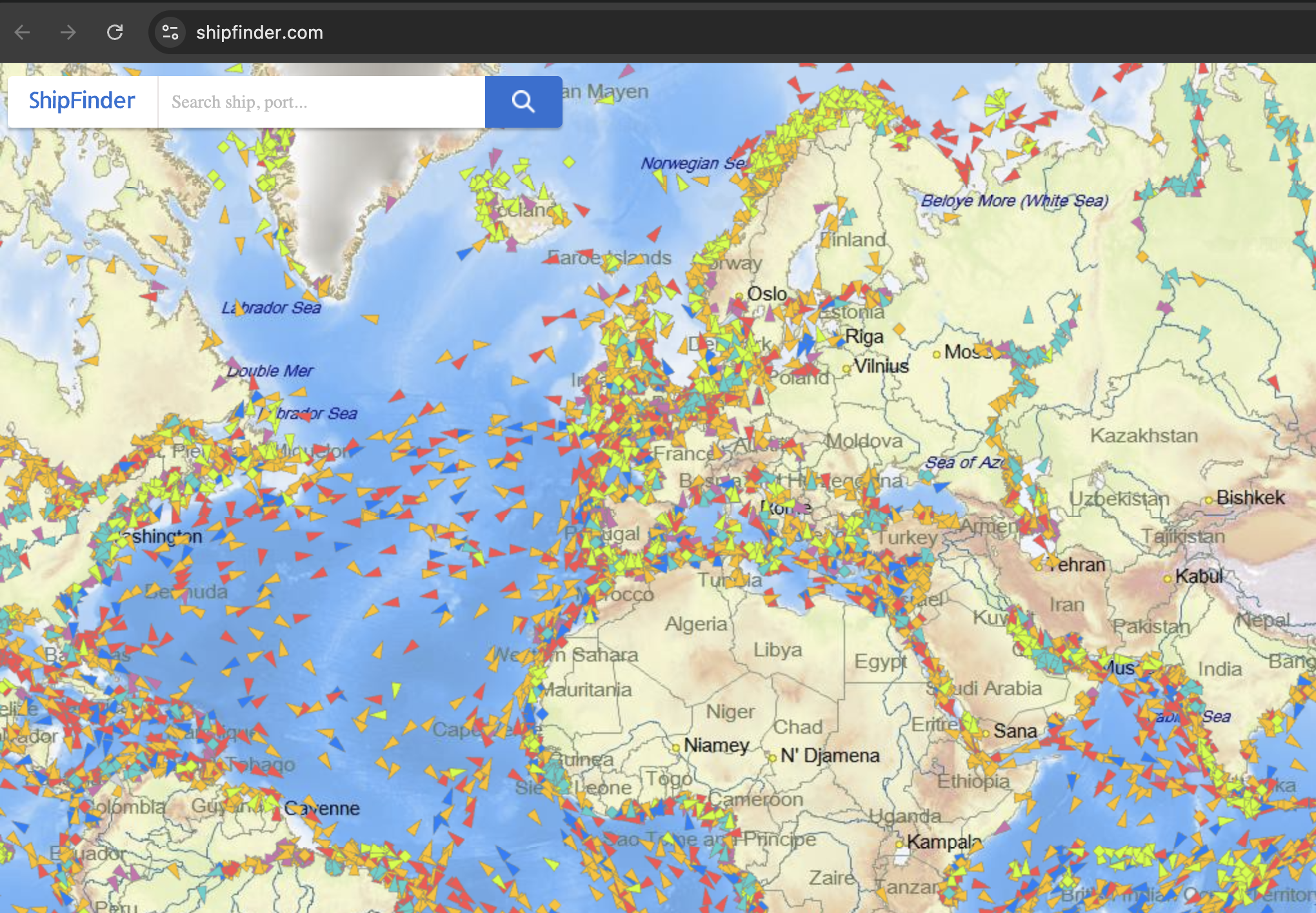
Figure 6. ShipFinder — a third, because where the tools disagree is where you learn something.
From a dot to a dossier
Click a single hull and the map stops being a map and becomes a file. Here is one vessel I pulled at random from the Mallorca anchorage — a 124-metre yacht flying the Qatari flag, name KATARA, sitting at anchor after an overnight hop from Barcelona to Palma.
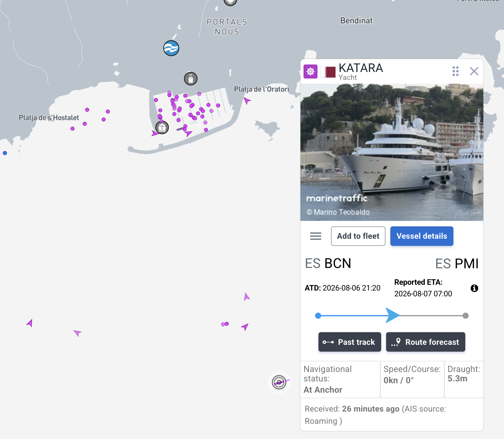
Figure 7. One click on a hull: type, flag, Barcelona→Palma, reported ETA, “At Anchor,” and buttons for Past track and Route forecast.
The card alone gives you the voyage: where it left, when, where it is going, when it expects to arrive, and whether it is moving or parked. Open the full page and it deepens into something closer to an intelligence product.
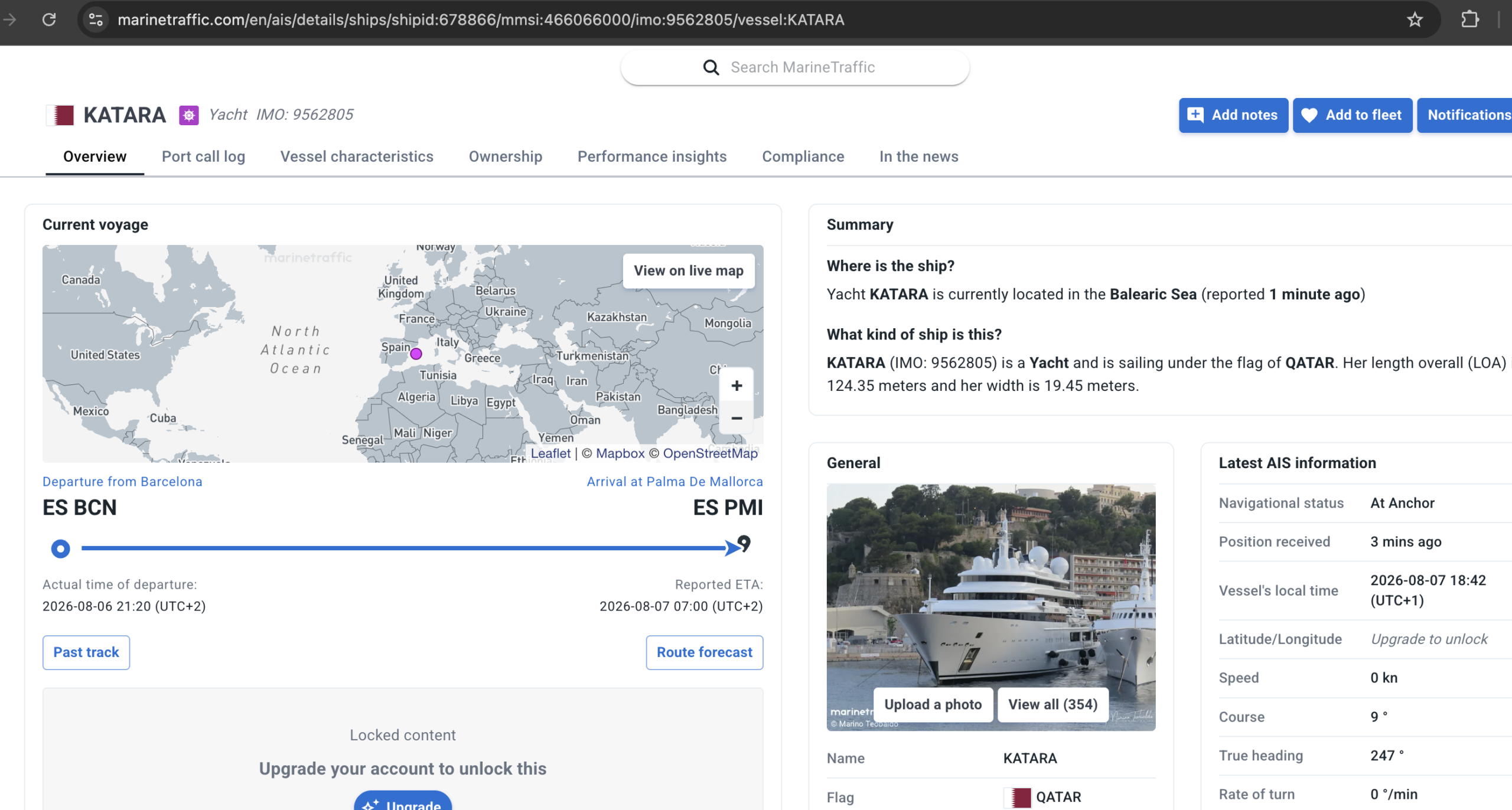
Figure 8. The full file: IMO 9562805, MMSI 466066000, 124 m, and tabs for Port call log, Ownership and “In the news.” The exact latitude/longitude sits behind “upgrade to unlock” — a paywall, not a privacy control.
Read that detail page like an attacker and it is a gift: a permanent identifier (the IMO number never changes, even if the vessel is renamed or reflagged), a complete history of every port it has called at, an Ownership tab, and a route forecast. The only thing hidden is the precise lat/long — and that is hidden to sell you a subscription, not to protect anyone. VesselFinder shows the same hull with its own particulars and, tellingly, its neighbours.
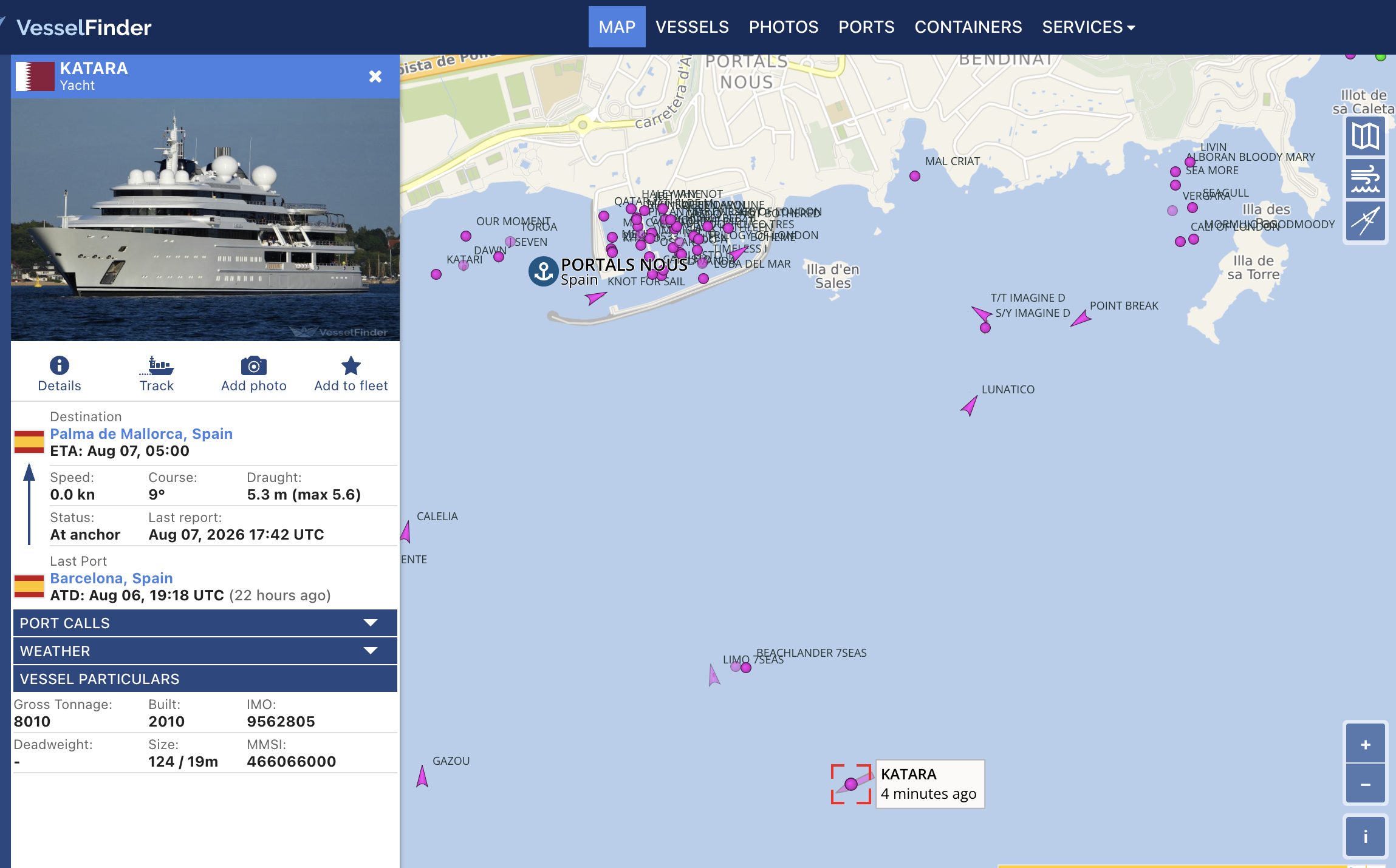
Figure 9. Not just one vessel — its neighbourhood. Who anchors near whom is its own kind of intelligence.
That last screenshot is the one that should worry a protection detail. You did not just find one vessel. You found its neighbourhood — who anchors near whom, which is its own kind of intelligence.
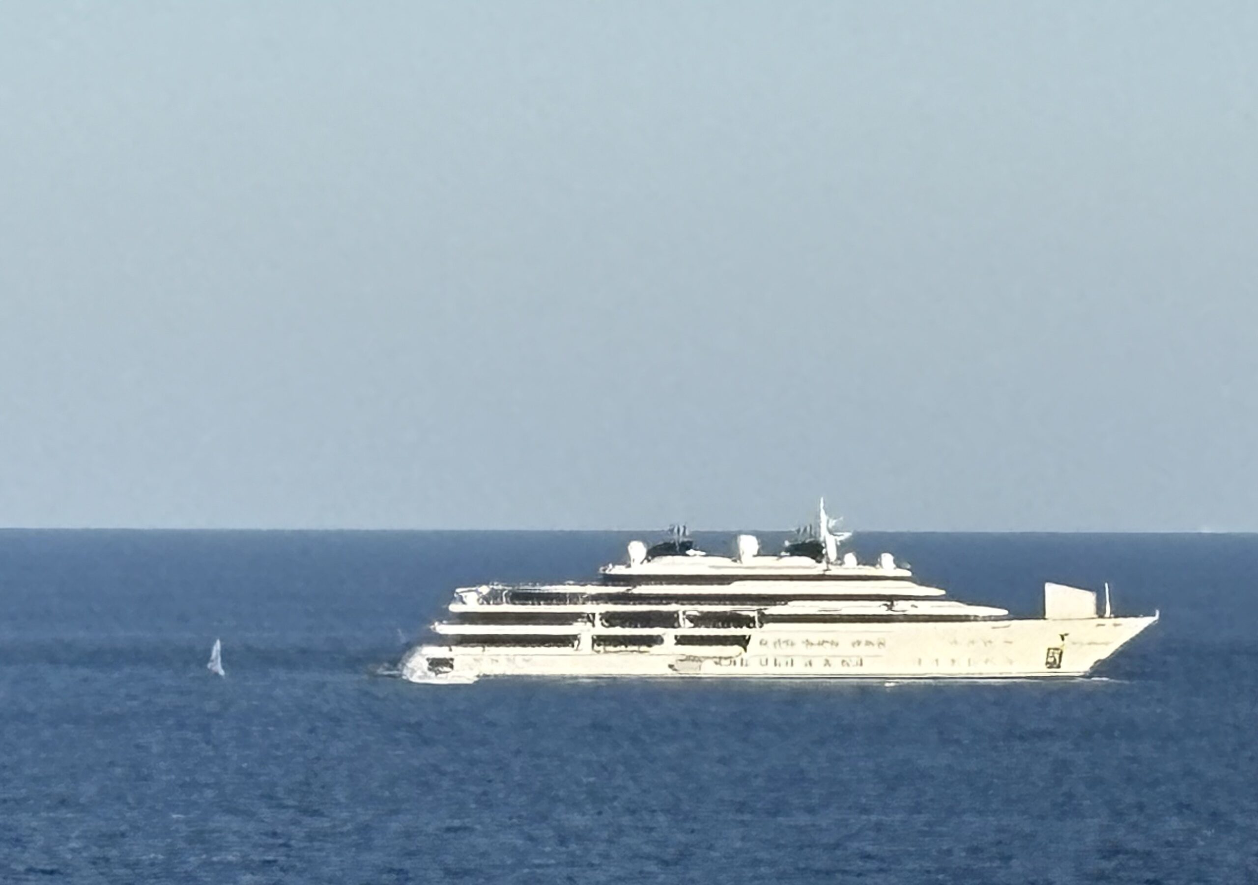
Figure 10. And here it is. The trackers said a 124-metre yacht was off Mallorca; a walk to the shoreline and a phone camera confirmed it. The data was never abstract — it was a hull you could stand and watch.
A second hull, same result
None of this is cherry-picked. Point the same three tools at the next dark hull in the bay and the file assembles itself again. This one is KISMET — a 122-metre yacht under the Marshall Islands flag, built in 2024, at anchor off Portals after a run down from Port Vendres.
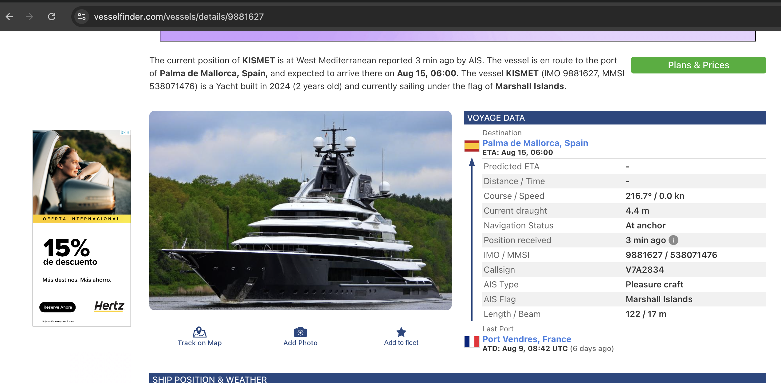
Figure 11. A different hull, the same dossier: IMO 9881627, MMSI 538071476, callsign V7A2834, Marshall Islands flag, 122×17 m — voyage, draught, and at-anchor status, all from one page.
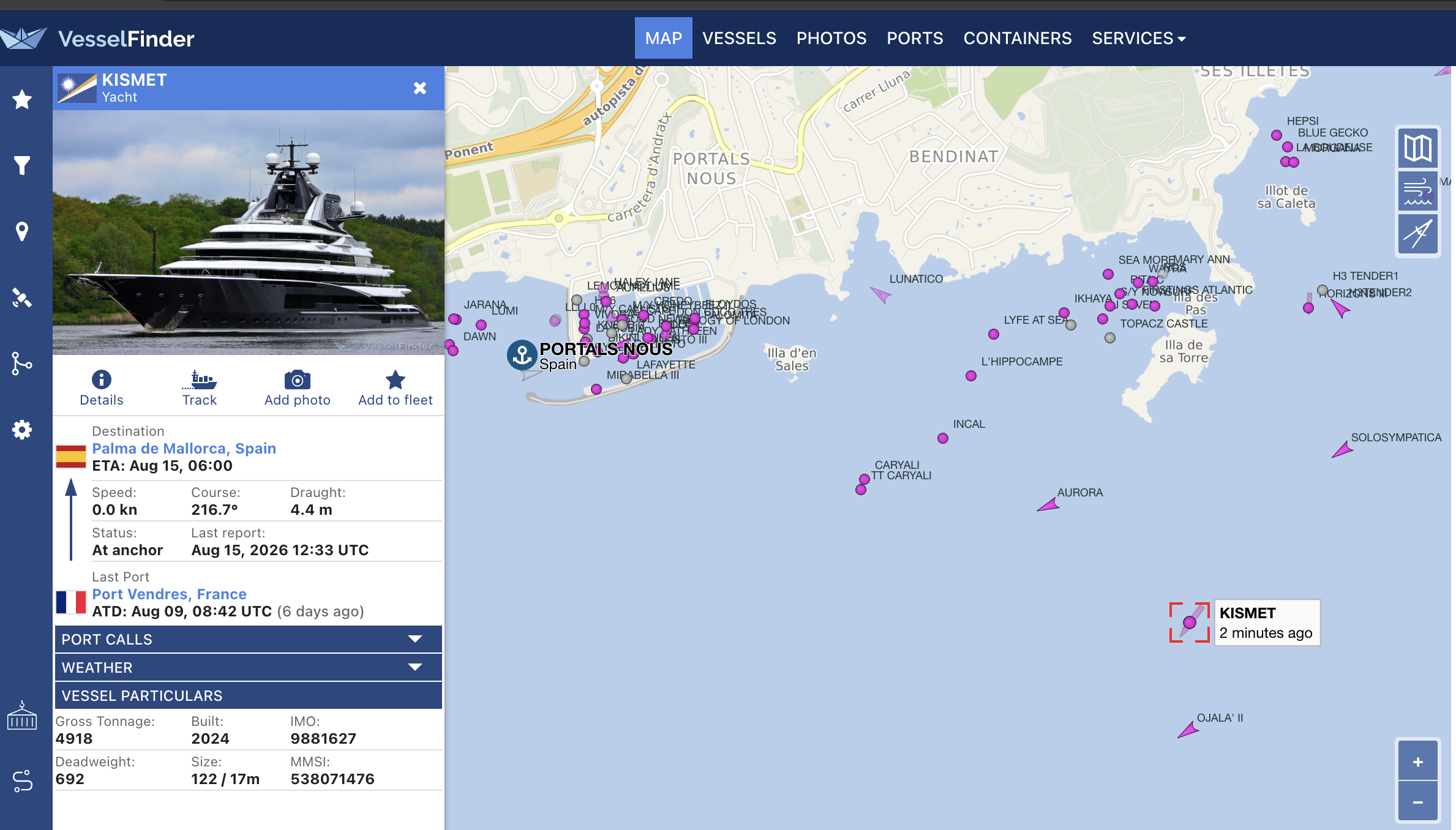
Figure 12. And its neighbourhood — KISMET at anchor in a bay the map has labelled with the name of nearly everything around it.
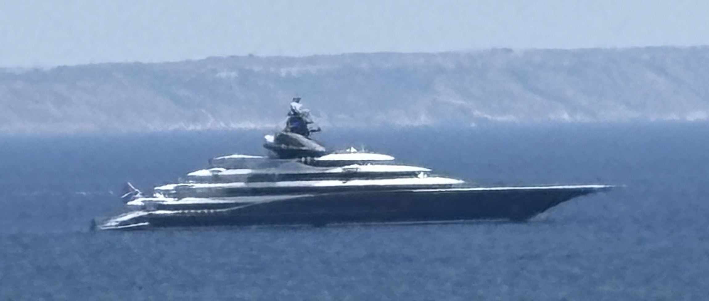
Figure 13. Same ending as before: the data said a 122-metre yacht was off Mallorca, and there it was from the shoreline. The method doesn’t care which hull you point it at.
From vessel to person
Tracking a hull is easy. The real OSINT work is the last hop: hull to human. It is a chain, and every link is public.
The IMO number gives you a permanent handle on the hull — it survives renaming and reflagging — while the MMSI tracks the current registration, so if it changes, that itself is a tell. From there you walk the flag and registry to a registered owner, which for any serious yacht is a management company or a holding entity in a friendly jurisdiction — a deliberate curtain. But the curtain has holes: yacht-owner directories such as SuperYachtFan exist specifically to map hulls to the people behind them and do the deanonymization for you; the press names owners every time a yacht is bought, sold, or involved in anything; and the vessel’s own In the news tab often hands you the connection directly. Cross-reference three public sources and the holding company stops hiding anyone.
I am deliberately not going to close that loop on a named individual here. The point is that the loop closes, cheaply, and that the people who most need to understand it are the ones aboard.
The part that defeats “just turn it off”: the radio
Here is where my old world — wardriving and RF, the stuff I have been doing since before it was fashionable — walks back into the story.
Everything above used websites. You don’t need them. AIS is just VHF radio on two channels (161.975 MHz and 162.025 MHz), and a PortaPack running the open-source Mayhem firmware decodes it passively, straight off the air — AIS Boats shows the MMSI, name, and the latest position each vessel transmits, with no account, no subscription, and no internet connection at all. A pocket device and an antenna, sitting quietly in a marina car park.
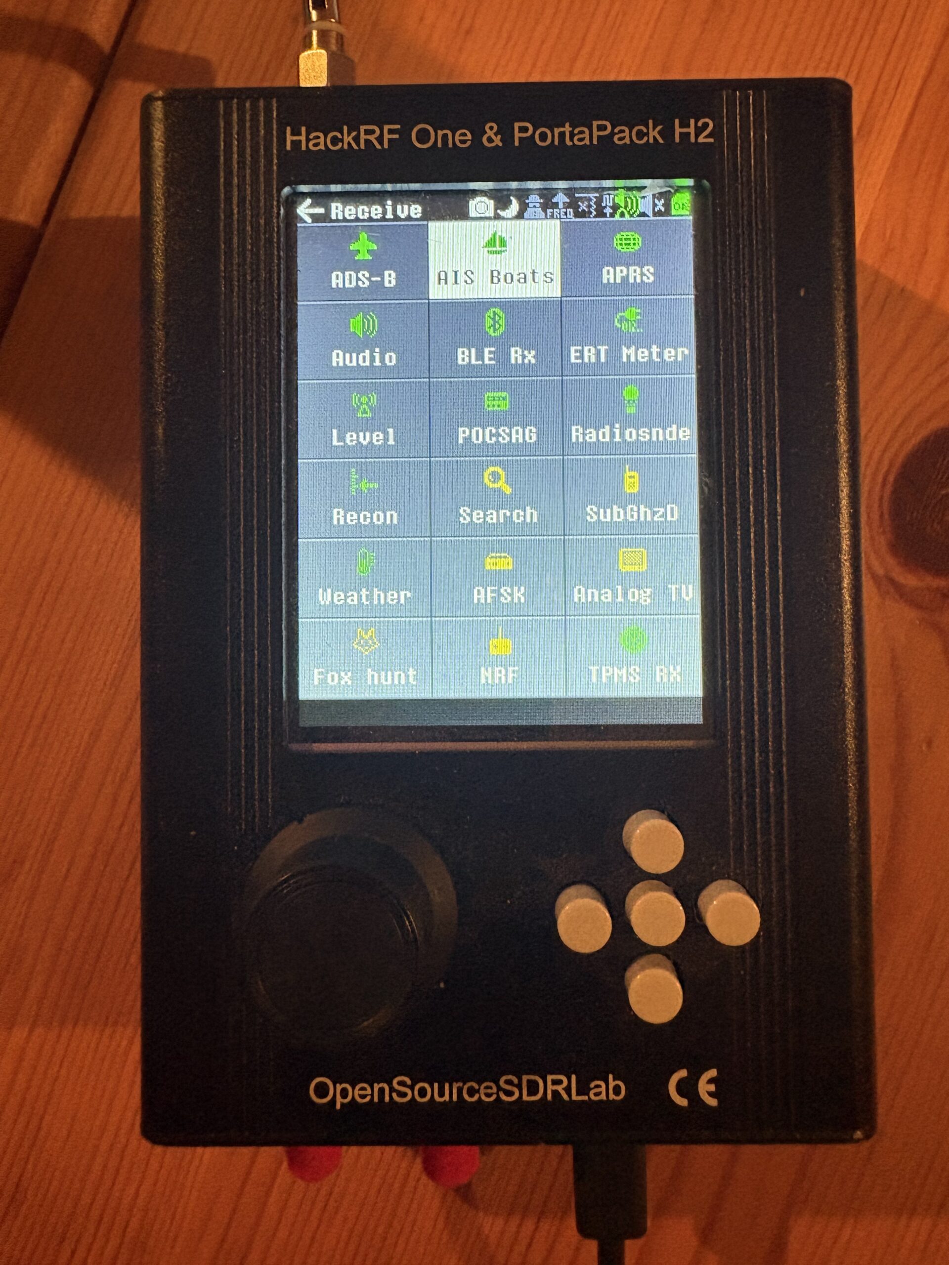
Figure 14. A HackRF One + PortaPack H2 running the open-source Mayhem firmware. AIS Boats is a built-in receive app — no PC, no internet.
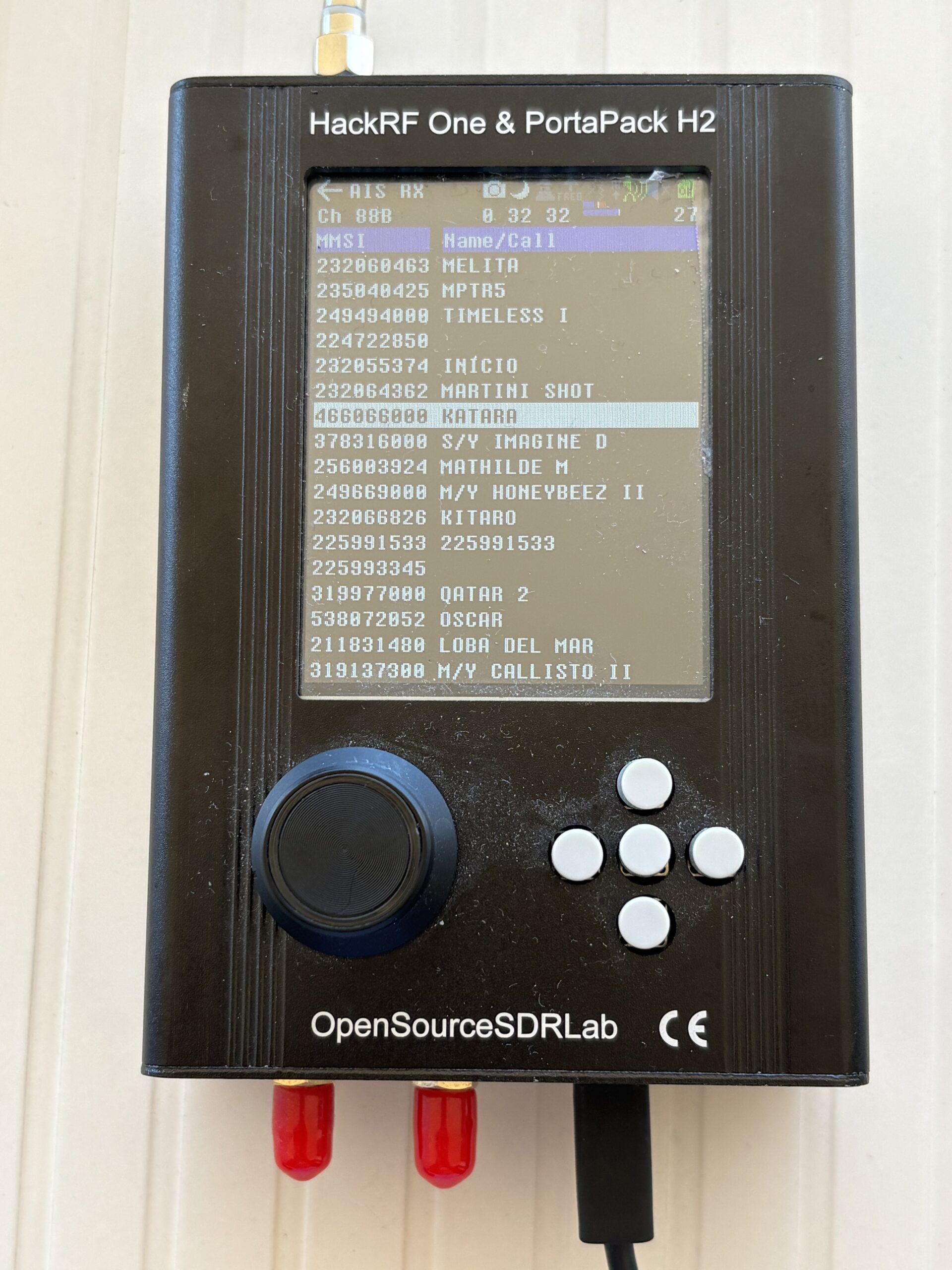
Figure 15. The same hulls, received passively off VHF — and there, highlighted, is KATARA (MMSI 466066000): the exact yacht we pulled off MarineTraffic a moment ago, now heard straight off the air. No account, no subscription.
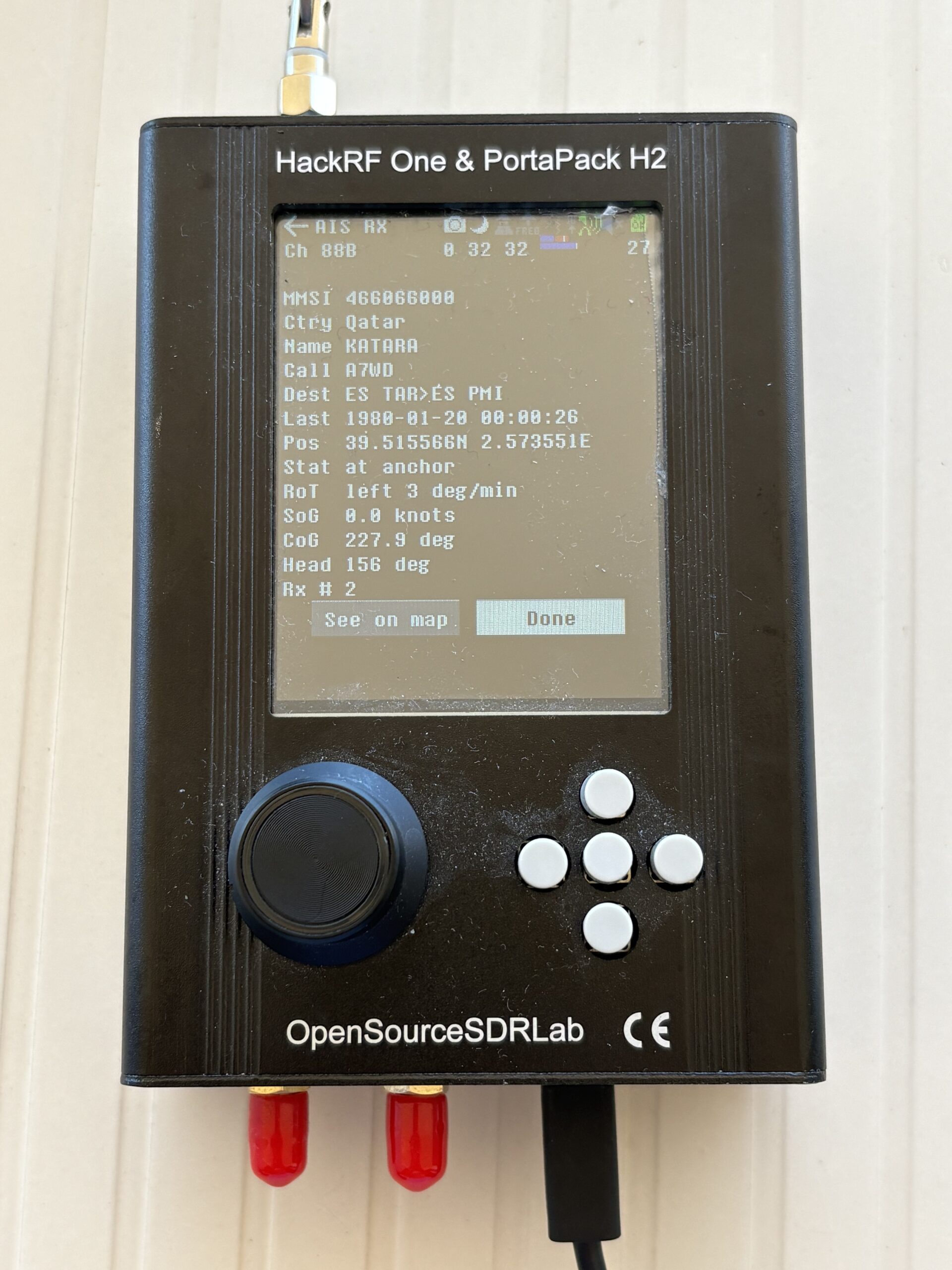
Figure 16. KATARA decoded straight off VHF: name, Qatari flag, MMSI 466066000, at anchor — and its exact position, 39.51°N 2.57°E, the very latitude/longitude MarineTraffic charged a subscription to hide.
And it isn’t a one-hull trick. Leave the receiver running and the bay fills itself in. There, in the live list of everything the antenna is hearing, is KISMET — the same 122-metre hull we pulled off VesselFinder a few sections ago, arriving now straight off the air, sitting in a car-park’s worth of its neighbours.
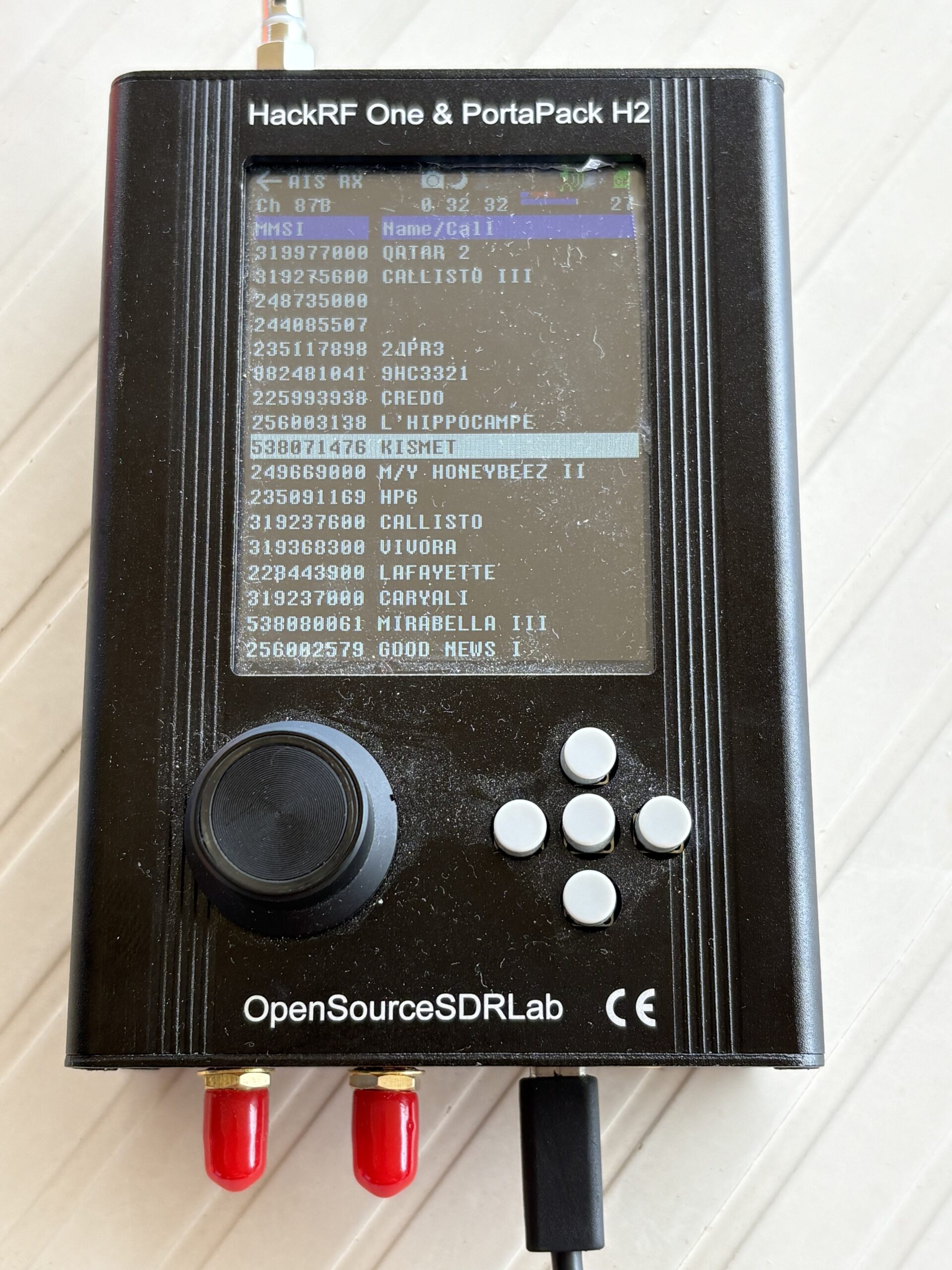
Figure 17. The live receive list on Channel 87B — and there, highlighted, is KISMET (MMSI 538071476), heard passively alongside QATAR 2, CALLISTO III, and a dozen other hulls the antenna plucked out of the air.
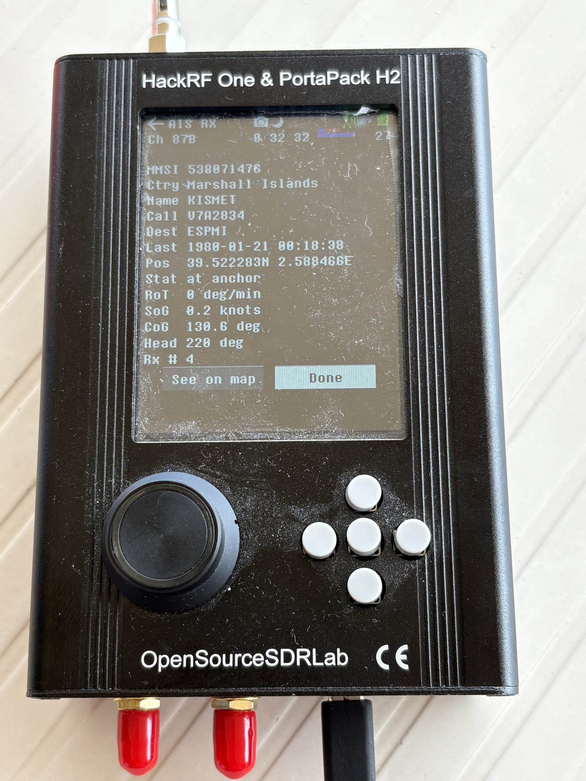
Figure 18. KISMET decoded straight off VHF: MMSI 538071476, callsign V7A2834, Marshall Islands, destination ESPMI (Palma), at anchor — and the exact position, 39.52°N 2.59°E, matching the VesselFinder page to the decimal.
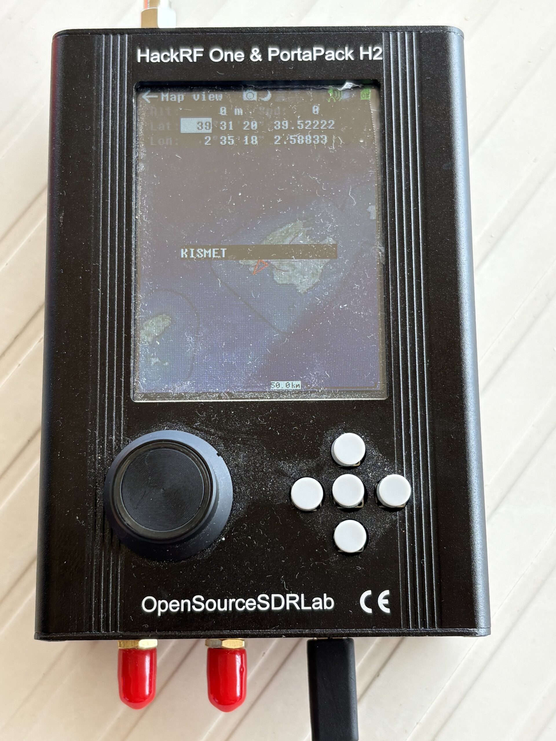
Figure 19. No website anywhere in the loop: the PortaPack takes the position it just decoded and plots KISMET on its own map. RF in, a dot on a chart out — offline, from a device that fits in a pocket.
This is the point that matters most for defense, so I will say it plainly: suppressing your vessel online is not radio silence. The aggregators offer opt-outs and privacy filters, and owners pay for them — but those only affect what the websites display. SOLAS still requires the transponder to transmit. Anyone within VHF range — a few miles, more from a hill or a drone — still receives the broadcast the website is politely hiding. You can pay MarineTraffic to stop showing you. You cannot pay physics to stop propagating you. And notice the twist in Figure 16: the precise position MarineTraffic put behind a paywall, the radio gives away for free. Paywall is not privacy, and opt-out is not silence.
One honest caveat, because it cuts both ways: AIS has no authentication. The same openness that lets you receive it lets anyone forge it — spoofed MMSIs, ghost positions, and vessels that simply switch off and go dark are a routine feature of sanctions-evasion “dark fleets.” For the tracker, that means the signal can lie. For the defender, it means deception is on the table too: where the law of your flag and waters allows it, a decoy track is a legitimate protective option.
Where AI changes the shape of the problem
Everything so far is 2016 OSINT with a 2026 coat of paint. Here is what actually makes this a new problem, and it is the thread that runs through everything else I write on this blog: the hard part of OSINT was never finding the data. It was correlating it. That is exactly the labor AI collapses.
Fusion into a live dossier. The manual version of this article is an analyst spending a week stitching AIS positions to an owner directory to news archives to a management-company filing to a crew member’s public Instagram. An agent does it in a prompt: give it a vessel name and it queries the trackers, pulls the owner directory, scrapes the news tab, correlates the social posts, and hands back a single profile. The week becomes a minute.
Pattern-of-life and prediction. The trackers already ship a route forecast button for a single voyage. Feed a model a season of historical AIS and it generalizes: this vessel summers in the Balearics and the Tyrrhenian, favours these three anchorages, moves on weekends, and — given the current track — is most likely headed here next. Tracking that used to report now predicts. A predicted anchorage, forty-eight hours out, is a place to position a camera, a boat, or something worse.
Deanonymization at scale. The hull-to-human chain I walked by hand is a cross-referencing task, which is what these models are unreasonably good at: point one at the registries, the leaks, the directories, and the news, and it bridges shell to owner faster than any curtain can be redrawn.
Vision geolocation. A guest posts a sunset from the aft deck. A vision model places the coastline, the marina, the mountain profile — and cross-references AIS to confirm the vessel was there. The boat can be “dark” online and still get put on the map by a stranger’s holiday photo.
Cross-domain correlation. The wealthy rarely arrive by sea. They fly in — private jet to the island, helicopter to the deck — and aircraft broadcast their own cousin of AIS called ADS-B, on 1090 MHz, which the same PortaPack in Figure 14 decodes too. Correlate the ADS-B track of a known tail number with the AIS track of a hull and you stop tracking a boat and start tracking a person: the jet lands, the helicopter hops to the anchorage, the owner is aboard. Sea plus sky is the difference between “the yacht is here” and “the principal is here, right now.”
The autonomous agent. Wire the above into a loop that runs unattended: watch for a target MMSI to reappear anywhere on the global feed, enrich it, and alert. This is the same shift I wrote about in When the Model Is the Attacker and How to Weaponize AI Agent Skills, pointed at the ocean: the adversary is no longer a person watching a screen. It is an agent that never sleeps and pages a human only when the target surfaces.
And the version that removes the last trace: the PortaPack captures AIS off the air, a local open model running on your own hardware enriches the raw MMSI into an identity, and nothing you did ever touched a website or left a query log. RF in, dossier out, entirely offline.
Who actually cares

Figure 20. The whole chain in one view — collect AIS (web or radio), resolve hull to person, enrich and predict with AI, act on the location. Every step uses public data and public tools; no step is “hacking.”
Name the threat model plainly, because “someone can see the boat” only lands when you attach it to intent. Kidnap-for-ransom crews and modern piracy plan around a known location. Stalkers and obsessives do not need much. Activists and paparazzi want the shot and the story. Business rivals want the meeting nobody announced — two yachts anchored together for a weekend is a signal. Sanctions and nation-state trackers do this at industrial scale already. In every case the output is the same: a place, a time, and a person who thought the sea made them unreachable.
The defensive playbook
None of this is an argument to panic. It is an argument to plan around reality, and the reality is that presence is knowable. Here is what I would tell a principal or a protection detail.
Treat AIS as an OPSEC decision, with a real safety trade-off. You can reduce transmission (silent/receive-only modes, or lawfully switching off in specific circumstances), but AIS exists to stop collisions — going dark trades a tracking risk for a safety risk, and in busy waters that is not a trade to make casually. Know the rules for your flag and your waters, and make it a deliberate decision, not a default.
Understand that obfuscation only half-works. Renaming, reflagging, and holding the vessel through a management company all raise the cost of attribution — but the IMO number is permanent, the directories catch up, and the press does the rest. Obfuscation buys time and friction, not invisibility. Budget accordingly.
The leak is usually a person, not the transponder. Crew and guest social media geolocates your vessel more reliably than AIS ever will. A published crew roster, a tagged sunset, a marina selfie — that is the exploit. OPSEC training for everyone aboard is worth more than any privacy subscription.
Turn the tools on yourself, first. Everything an adversary can build, you can build defensively. Run the fusion agent against your own vessel, geofence it, and alert yourself when your footprint becomes trackable or when the pattern-of-life gets too predictable. Vary the routine the model is trying to learn. Monitor your own exposure the way the other side monitors it.
Accept the physics and protect around it. You can suppress the website; you cannot suppress the VHF. Plan protection on the assumption that a motivated party can know when and roughly where the vessel is — because with a cheap radio and an AI agent, they can.
So what
The sea used to feel private because it was empty. It isn’t anymore. A safety beacon that vessels are required by law to transmit, four free websites, a two-hundred-euro radio, and an AI agent that never sleeps turn an ocean into an address book — and the entries are some of the most protected people on earth, publishing their coordinates on an open channel every thirty seconds.
The uncomfortable part is that there is no vulnerability to patch here. Nothing is broken. AIS is supposed to do this; the tools are legal; the data is public; the AI just makes the correlation instant. That is precisely why it belongs on a security blog and not in a headline about a hack. The exposure is structural, the mitigation is operational, and the people who need to understand it are the ones who assume that money and a hull between them and the shore add up to privacy.

Figure 21. Why it’s structural, not a bug — a broadcast the law requires, an opt-out that isn’t radio silence, and a public hull-to-human chain feed one pipeline, from a mandated safety signal to a person, place, and time.
They don’t. Assume you’re broadcasting — because you are.
Stay paranoid. Watch your own signal. Vary the routine.
- X (Twitter): @SimonRoses
Further Reading:
- SpecialEurasia — OSINT Tools for Maritime Intelligence
- PortaPack Mayhem firmware — AIS Boats (wiki)
- MarineTraffic · VesselFinder · ShipFinder · Maritime Database
- IMO — AIS overview
Questions or feedback? Reach out via:
- Website: vulnex.com
- AI Security Strategy: vulnex.ai
- Twitter/X: @SimonRoses
- LinkedIn: linkedin.com/in/simonroses
- GitHub: github.com/vulnex
Contact: info@vulnex.com